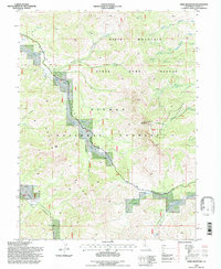
1994 Map of Dixie Mountain
USGS Topo · Published 1997About this map
Dixie Mountain and the high ridges of the Plumas National Forest dominate this 1990s landscape, illustrating a wilderness area managed for multiple uses including wildlife protection and recreation. The map highlights the State Game Refuge that spans the northern slopes, while the presence of the Dixie Mountain Lookout and the Lookout Trail indicate the historical importance of fire surveillance in these timberlands. Down in the southeastern corner, the terrain transitions toward the water at Frenchman Cove and Frenchman Lake, where Frenchman Creek enters the reservoir. A network of canyons including Ross Canyon, Horton Canyon, and Dotta Canyon carve through the high elevations of Horton Ridge, showing the complex drainage systems that feed into Dixie Valley and the surrounding basins.
Find a feature on this map
25 named features on this map. Tap any name to fly to it.
Don’t see what you’re looking for? This feature index may not catch every label — zoom into the map to look around manually.
Map Details
Editions of this 1994 Dixie Mountain Map
This is the sole edition of this map. No revisions or reprints were ever made.
Other maps of this area

1886 · Honey Lake
USGS Topo · 1:250,000

1890 · Sierraville
USGS Topo · 1:125,000

1891 · Honey Lake
USGS Topo · 1:250,000

1892 · Sierraville
USGS Topo · 1:125,000

1893 · Honey Lake
USGS Topo · 1:250,000

1894 · Sierraville
USGS Topo · 1:125,000

1950 · Chilcoot
USGS Topo · 1:62,500

1950 · Portola
USGS Topo · 1:62,500

1950 · Milford
USGS Topo · 1:62,500

1954 · Doyle
USGS Topo · 1:62,500