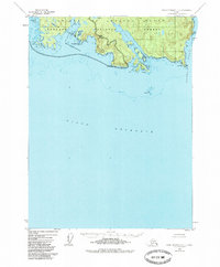
1948 Map of Dixon Entrance C-1
USGS Topo · Published 1985About this map
Prince of Wales Island meets the open waters of the Dixon Entrance and Clarence Strait in this topographic study, based on 1948 aerial photography with minor revisions through 1985. The coastal fringe is defined by an intricate network of waterways like Nichols Bay and Brownson Bay, separated by high points such as Nichols Mountain. The map details the transition from the protected timberlands of the Tongass National Forest and the South Prince of Wales Wilderness to the treacherous offshore features like Nunez Rks and White Rks. Mariners and local historians can trace the specific naming of coastal landmarks, from Cape Chacon at the island's tip to internal passages like the Bert Millar Cutoff and Minnie Cutoff, illustrating how the marine geography dictated movement and naming conventions in this maritime environment.
Find a feature on this map
25 named features on this map. Tap any name to fly to it.
Don’t see what you’re looking for? This feature index may not catch every label — zoom into the map to look around manually.
Map Details
Editions of this 1948 Dixon Entrance C-1 Map
3 editions found
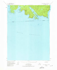
Other maps of this area

1948 · Dixon Entrance D-2
USGS Topo · 1:63,360

1948 · Prince Rupert D-6
USGS Topo · 1:63,360

1948 · Dixon Entrance C-1
USGS Topo · 1:63,360

1948 · Dixon Entrance D-1
USGS Topo · 1:63,360

1951 · Prince Rupert
USGS Topo · 1:250,000

1951 · Dixon Entrance
USGS Topo · 1:250,000

1951 · Dixon Entrance D-2
USGS Topo · 1:63,360

1951 · Prince Rupert D-6
USGS Topo · 1:63,360

1959 · Dixon Entrance
USGS Topo · 1:250,000

1959 · Prince Rupert
USGS Topo · 1:250,000