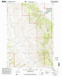
1997 Map of Dixon Mountain
USGS Topo · Published 2002About this map
The Tendoy Mountains dominate this landscape within the Beaverhead National Forest, defined by a series of high-elevation ridges and drainages. Dixon Mountain and Timber Butte serve as primary anchors for the topography, while water sources like Big Sheep Creek and Muddy Creek carve through the deep canyons. This 1997 revision of a 1965 survey highlights the primitive transportation network of the Dillon Ranger District, where the Prospect Trail and Hidden Pasture Trail provide access to the high country. Small-scale mining activity is indicated by several Prospect labels throughout the terrain, suggesting early 20th-century exploration for mineral deposits. To the southeast, White Pine Ridge and Deadwood Gulch emphasize the remote character of this mountain range on the edge of the Continental Divide.
Find a feature on this map
26 named features on this map. Tap any name to fly to it.
Don’t see what you’re looking for? This feature index may not catch every label — zoom into the map to look around manually.
Map Details
Editions of this 1997 Dixon Mountain Map
This is the sole edition of this map. No revisions or reprints were ever made.
Other maps of this area

1955 · Dubois
USGS Topo · 1:250,000

1958 · Dubois
USGS Topo · 1:250,000

1965 · Kidd
USGS Topo · 1:24,000

1965 · Caboose Canyon
USGS Topo · 1:24,000

1965 · Gallagher Gulch
USGS Topo · 1:24,000

1965 · Briggs Ranch
USGS Topo · 1:24,000

1965 · Graphite Mountain
USGS Topo · 1:24,000

1965 · Deer Canyon
USGS Topo · 1:24,000

1965 · Dixon Mountain
USGS Topo · 1:24,000

1965 · Dell
USGS Topo · 1:24,000