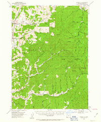
1954 Map of Dixonville
USGS Topo · Published 1963About this map
Dixonville and Singleton Valley serve as the primary human touchpoints in this mid-century portrait of Douglas County. The landscape is defined by the deep incisions of Deer Creek and North Myrtle Creek, where the resource-based economy of the 1950s is evidenced by a Sawmill and the Chieftain Mine. Farther south, the Continental Mine and a local Reservoir mark the industrial activity within the Umpqua National Forest. Rural infrastructure is well-preserved here, from the Cedar Grove Church and a local School to a Grange Hall and a remote Landing Strip. The map also captures the transition from settled valleys to the high points of Lane Mtn and Buck Peak, connected by a network of unimproved roads and the Buck Fk Trail.
Find a feature on this map
72 named features on this map. Tap any name to fly to it.
Don’t see what you’re looking for? This feature index may not catch every label — zoom into the map to look around manually.
Map Details
Editions of this 1954 Dixonville Map
2 editions found
Other maps of this area

1891 · Ashland
USGS Topo · 1:250,000

1893 · Ashland
USGS Topo · 1:250,000

1897 · Roseburg
USGS Topo · 1:125,000

1897 · Ashland
USGS Topo · 1:250,000

1900 · Roseburg
USGS Topo · 1:125,000

1904 · Riddle
USGS Topo · 1:125,000

1944 · Tiller
USGS Topo · 1:62,500

1954 · Dixonville
USGS Topo · 1:62,500

1954 · Sutherlin
USGS Topo · 1:62,500

1954 · Days Creek
USGS Topo · 1:62,500