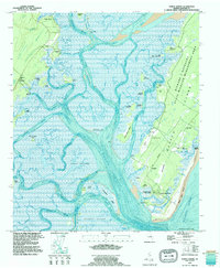
1993 Map of Doboy Sound
USGS Topo · Published 1995About this map
The labyrinthine tidal estuaries and marshlands of coastal McIntosh County dominate this mid-1990s survey. Sapelo Island occupies the eastern portion of the sheet, where historic cultural sites like the First African Ch and Behaviour Cem sit alongside the traditional Gullah-Geechee community at Hog Hammock. The landscape is a complex network of deep-water channels and hammocks, including Teakettle Creek and the Mud River, which separate the mainland settlements of Valona and Meridian from the barrier island.
Find a feature on this map
67 named features on this map. Tap any name to fly to it.
Don’t see what you’re looking for? This feature index may not catch every label — zoom into the map to look around manually.
Map Details
Editions of this 1993 Doboy Sound Map
This is the sole edition of this map. No revisions or reprints were ever made.
Other maps of this area

1920 · Sapelo River
USGS Topo · 1:62,500

1920 · Cabretta Island
USGS Topo · 1:62,500

1921 · Darien
USGS Topo · 1:62,500

1928 · St Catherines Island
USGS Topo · 1:62,500

1943 · St Catherines Island
USGS Topo · 1:62,500

1943 · Sapelo River
USGS Topo · 1:62,500

1944 · Cabretta Island
USGS Topo · 1:62,500

1945 · St. Catherine's Island
USGS Topo · 1:62,500

1945 · Sapelo River
USGS Topo · 1:62,500

1946 · Brunswick
USGS Topo · 1:250,000