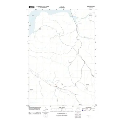
2011 Map of Dodge
USGS Topo · Published 2011About this map
Pataha Creek flows through a landscape defined by sharp elevation changes and agricultural utility in this corner of Garfield County. The small settlement of Dodge sits at a strategic junction near Dodge Hill, while the Pataha Valley Grange and Scott Seed Farm Airport reflect the area’s persistent farming roots. To the northwest, the Snake River corridor is dominated by Lake Bryan, where the Port of Garfield serves as a vital point for river commerce. Historical place names like New York Bar and New York Island suggest a legacy of early river navigation and trade. The surrounding terrain is heavily dissected by numerous drainages, including Deadman Creek, Meadow Creek, and New York Gulch, illustrating the rugged drainage patterns that separate local plateaus like Kuhl Ridge from the fertile Pataha Valley.
Find a feature on this map
29 named features on this map. Tap any name to fly to it.
Don’t see what you’re looking for? This feature index may not catch every label — zoom into the map to look around manually.
Map Details
Editions of this 2011 Dodge Map
This is the sole edition of this map. No revisions or reprints were ever made.
Other maps of this area

1937 · Pomeroy
USGS Topo · 1:96,000

1942 · Pomeroy
USGS Topo · 1:125,000

1950 · Penawawa
USGS Topo · 1:62,500

1950 · Hay
USGS Topo · 1:62,500

1952 · Hay
USGS Topo · 1:62,500

1955 · Pullman
USGS Topo · 1:250,000

1958 · Pullman
USGS Topo · 1:250,000

1967 · Turner
USGS Topo · 1:24,000
1967 · Zumwalt
USGS Topo · 1:24,000
1967 · Tucannon
USGS Topo · 1:24,000