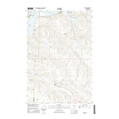
2017 Map of Dodge
USGS Topo · Published 2017About this map
Snake River geography dominates this 2017 survey where the borders of Garfield, Whitman, and Columbia counties converge. The northern edge of the map features Lake Bryan and the historic river crossing at Central Ferry, while the southern reaches are defined by the high elevations of Kuhl Ridge and Dodge Hill. The interior landscape is deeply incised by drainages like Deadman Cr and Pataha Cr, which run through a series of namesake canyons such as Phalen Gulch and Miller Gulch. Small settlements and rail points like Dodge, Chard, and Houser are tucked into these valleys, illustrating the historical reliance on creek-side routes for transport and commerce. Geologists and local historians will find the naming conventions like New York Bar and New York Island indicative of early river traffic and land claims in this part of Washington.
Find a feature on this map
35 named features on this map. Tap any name to fly to it.
Don’t see what you’re looking for? This feature index may not catch every label — zoom into the map to look around manually.
Map Details
Editions of this 2017 Dodge Map
This is the sole edition of this map. No revisions or reprints were ever made.
Other maps of this area

1937 · Pomeroy
USGS Topo · 1:96,000

1942 · Pomeroy
USGS Topo · 1:125,000

1950 · Penawawa
USGS Topo · 1:62,500

1950 · Hay
USGS Topo · 1:62,500

1952 · Hay
USGS Topo · 1:62,500

1955 · Pullman
USGS Topo · 1:250,000

1958 · Pullman
USGS Topo · 1:250,000

1967 · Turner
USGS Topo · 1:24,000
1967 · Zumwalt
USGS Topo · 1:24,000
1967 · Tucannon
USGS Topo · 1:24,000