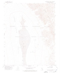
1973 Map of Dog Bone Lake North
USGS Topo · Published 1977About this map
Dog Bone Lake occupies the center of this 1970s topographic study, situated within the broad expanse of Three Lakes Valley. This arid landscape is defined by the intersection of military and conservation interests, with the boundaries of the Nellis Air Force Range overlapping the Desert National Wildlife Range. The terrain transitions from the flat playa of the lakebed to the steep, complex contours of the Desert Range rising to the east. Several specific points are marked as Target Areas within the valley, reflecting the area's use for military training and aerial testing. Infrastructure is sparse, consisting primarily of a single Jeep Trail cutting across the northwestern quadrant. The map provides a precise look at these Restricted lands before modern developments, showing the natural drainage patterns and topographical relief that dictate movement through this part of Lincoln County.
Find a feature on this map
8 named features on this map. Tap any name to fly to it.
Don’t see what you’re looking for? This feature index may not catch every label — zoom into the map to look around manually.
Map Details
Editions of this 1973 Dog Bone Lake North Map
This is the sole edition of this map. No revisions or reprints were ever made.
Other maps of this area

1907 · Las Vegas
USGS Topo · 1:250,000

1908 · Las Vegas
USGS Topo · 1:250,000

1942 · Emigrant Valley
USGS Topo · 1:125,000

1942 · Indian Spring
USGS Topo · 1:125,000

1945 · Sheep Range
USGS Topo · 1:125,000

1945 · Alamo
USGS Topo · 1:125,000

1954 · Caliente
USGS Topo · 1:250,000

1954 · Las Vegas
USGS Topo · 1:250,000

1957 · Las Vegas
USGS Topo · 1:250,000

1959 · Caliente
USGS Topo · 1:250,000