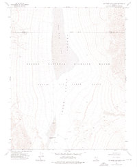
1973 Map of Dog Bone Lake South
USGS Topo · Published 1976About this map
The Desert National Wildlife Range and Nellis Air Force Range dominate this 1970s landscape, where military and conservation boundaries meet across a high desert basin. The northern portion of the map is defined by the seasonally dry Dog Bone Lake within Dog Bone Valley, while the southern end transitions into the Three Lakes Valley featuring the Three Lakes Valley Reservoir.
Find a feature on this map
11 named features on this map. Tap any name to fly to it.
Don’t see what you’re looking for? This feature index may not catch every label — zoom into the map to look around manually.
Map Details
Editions of this 1973 Dog Bone Lake South Map
This is the sole edition of this map. No revisions or reprints were ever made.
Other maps of this area

1907 · Las Vegas
USGS Topo · 1:250,000

1908 · Las Vegas
USGS Topo · 1:250,000

1942 · Indian Spring
USGS Topo · 1:125,000

1945 · Sheep Range
USGS Topo · 1:125,000

1954 · Las Vegas
USGS Topo · 1:250,000

1957 · Las Vegas
USGS Topo · 1:250,000

1959 · Las Vegas
USGS Topo · 1:250,000

1962 · Las Vegas
USGS Topo · 1:250,000
1973 · White Sage Flat
USGS Topo · 1:24,000
1973 · Heavens Well
USGS Topo · 1:24,000