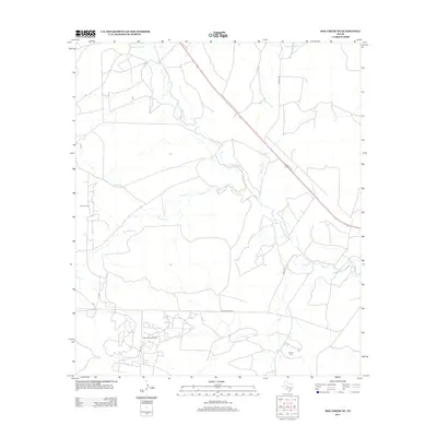
2012 Map of Dog Creek NE
USGS Topo · Published 2012About this map
The N Concho River winds through this West Texas landscape, defining a terrain dominated by the region's energy production. Extensive petroleum infrastructure is centered around the Water Valley Oil Field in the south and the Clark Oil Field to the northwest, revealing the intensive land use required for oil extraction in Tom Green County. A network of rural routes, including Ranch Road 2034 and Sisco Rd, connects these industrial sites across a watershed drained by numerous seasonal tributaries. Creeks such as Coyote Cr, Mulberry Cr, and Walnut Cr carve through the plains, highlighting the drainage patterns that dictate the placement of local roads and drilling operations. The proximity of the Hall Oil Field further illustrates the dense concentration of mineral resources that have shaped the area's modern development and physical footprint.
Find a feature on this map
13 named features on this map. Tap any name to fly to it.
Don’t see what you’re looking for? This feature index may not catch every label — zoom into the map to look around manually.
Map Details
Editions of this 2012 Dog Creek NE Map
This is the sole edition of this map. No revisions or reprints were ever made.
Other maps of this area

1954 · San Angelo
USGS Topo · 1:250,000

1957 · Carlsbad
USGS Topo · 1:62,500

1958 · San Angelo
USGS Topo · 1:250,000

1965 · San Angelo
USGS Topo · 1:250,000

1972 · Sterling City
USGS Topo · 1:24,000

1972 · Dog Creek NE
USGS Topo · 1:24,000

1972 · Dog Creek SW
USGS Topo · 1:24,000

1972 · Broome
USGS Topo · 1:24,000

1972 · Dog Creek NW
USGS Topo · 1:24,000
1972 · Dog Creek
USGS Topo · 1:24,000