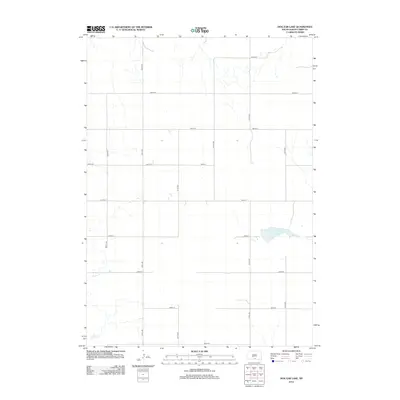
2012 Map of Dog Ear Lake
USGS Topo · Published 2012About this map
Dog Ear Lake provides a primary focal point in this portion of Tripp County, South Dakota. The landscape is defined by the section-line road grid, where numeric routes like 309th Ave and 292nd St intersect to form the agrarian infrastructure of the High Plains. This geometric precision of the late twentieth and early twenty-first centuries illustrates how the Great Plains were systematically organized for agriculture and settlement. Aside from the lake, the natural drainage of Willow Cr meanders across the southern and western portions of the sheet, providing a sharp contrast to the rigid straight lines of the surrounding transportation network. This map captures the rural character of the region, showing the scattered points of activity connected by a persistent network of unpaved and local roads through the prairie.
Find a feature on this map
17 named features on this map. Tap any name to fly to it.
Don’t see what you’re looking for? This feature index may not catch every label — zoom into the map to look around manually.
Map Details
Editions of this 2012 Dog Ear Lake Map
This is the sole edition of this map. No revisions or reprints were ever made.
Other maps of this area

1955 · Martin
USGS Topo · 1:250,000

1955 · Mitchell
USGS Topo · 1:250,000

1958 · Martin
USGS Topo · 1:250,000

1959 · Mitchell
USGS Topo · 1:250,000
1982 · Wewela
USGS Topo · 1:24,000

1982 · Witten SE
USGS Topo · 1:25,000
1982 · Millboro
USGS Topo · 1:24,000

1982 · Keyapaha SE
USGS Topo · 1:24,000

1982 · Winner South
USGS Topo · 1:25,000
1982 · Wewela NE
USGS Topo · 1:24,000