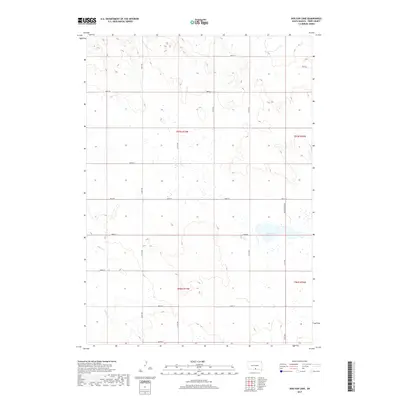
2017 Map of Dog Ear Lake
USGS Topo · Published 2017About this map
Dog Ear Lake serves as the central focal point of this Tripp County landscape, surrounded by an expansive network of sectional roads. The terrain is defined by the ephemeral drainage of Willow Creek, which winds through the western portion of the quadrangle. This 2017 survey reflects a largely agricultural environment, organized by a rigid grid of rural thoroughfares including 294th St and 310th Ave. These roads provide access to the various sections across Townships 96 and 97 North. Unlike many prairie regions with clustered settlements, this area maintains its character through its water bodies and the persistent infrastructure of the public land survey system, such as Dog Ear Lake Road, which borders the lake's eastern shore.
Find a feature on this map
20 named features on this map. Tap any name to fly to it.
Don’t see what you’re looking for? This feature index may not catch every label — zoom into the map to look around manually.
Map Details
Editions of this 2017 Dog Ear Lake Map
This is the sole edition of this map. No revisions or reprints were ever made.
Other maps of this area

1955 · Martin
USGS Topo · 1:250,000

1955 · Mitchell
USGS Topo · 1:250,000

1958 · Martin
USGS Topo · 1:250,000

1959 · Mitchell
USGS Topo · 1:250,000
1982 · Wewela
USGS Topo · 1:24,000

1982 · Witten SE
USGS Topo · 1:25,000
1982 · Millboro
USGS Topo · 1:24,000

1982 · Keyapaha SE
USGS Topo · 1:24,000

1982 · Winner South
USGS Topo · 1:25,000
1982 · Wewela NE
USGS Topo · 1:24,000