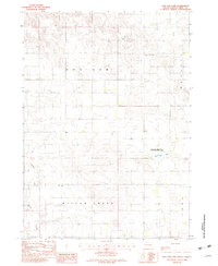
1982 Map of Dog Ear Lake
USGS Topo · Published 1983About this map
Dog Ear Lake serves as the central anchor of this Tripp County landscape, which transitions between the high plains and the Dog Ear Lake State Game Production Area. The pattern of settlement in the early 1980s is defined by isolated rural institutions and resource extraction, including a Gravel Pit and scattered rural schoolhouses such as North East Washington Sch and Willow Creek Sch. The terrain is drained by the meandering Willow Creek, which flows through the Willow Creek and Dog Ear townships. The presence of the Lakeview Ch near the lake suggests a community center for the surrounding ranching and farming homesteads that populate the Mc Neely and Dog Ear districts.
Find a feature on this map
12 named features on this map. Tap any name to fly to it.
Don’t see what you’re looking for? This feature index may not catch every label — zoom into the map to look around manually.
Map Details
Editions of this 1982 Dog Ear Lake Map
This is the sole edition of this map. No revisions or reprints were ever made.
Other maps of this area

1955 · Martin
USGS Topo · 1:250,000

1955 · Mitchell
USGS Topo · 1:250,000

1958 · Martin
USGS Topo · 1:250,000

1959 · Mitchell
USGS Topo · 1:250,000
1982 · Wewela
USGS Topo · 1:24,000

1982 · Witten SE
USGS Topo · 1:25,000
1982 · Millboro
USGS Topo · 1:24,000

1982 · Keyapaha SE
USGS Topo · 1:24,000

1982 · Winner South
USGS Topo · 1:25,000
1982 · Wewela NE
USGS Topo · 1:24,000