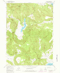
1964 Map of Dog Lake
USGS Topo · Published 1980About this map
Dog Lake sits at the center of this 1964 survey of the southern Oregon high country, surrounded by the administrative and ranching infrastructure of the Fremont National Forest. This landscape is defined by its water sources, with numerous family-named landmarks such as Nick Barry Spring, Hunter Spring, and Jerry Spring indicating a history of cattle ranging and forest management. The presence of the Dog Lake Work Center and a Guard Station near the lake's western shore highlights the region's importance as a hub for forestry operations during the mid-20th century.
Find a feature on this map
45 named features on this map. Tap any name to fly to it.
Don’t see what you’re looking for? This feature index may not catch every label — zoom into the map to look around manually.
Map Details
Editions of this 1964 Dog Lake Map
2 editions found
Other maps of this area

1886 · Alturas
USGS Topo · 1:250,000

1892 · Alturas
USGS Topo · 1:250,000

1954 · Alturas
USGS Topo · 1:250,000

1955 · Klamath Falls
USGS Topo · 1:250,000

1958 · Alturas
USGS Topo · 1:250,000

1958 · Klamath Falls
USGS Topo · 1:250,000

1960 · Strawberry Butte
USGS Topo · 1:62,500

1962 · Alturas
USGS Topo · 1:250,000

1962 · Steele Swamp
USGS Topo · 1:62,500

1962 · South Mountain
USGS Topo · 1:62,500