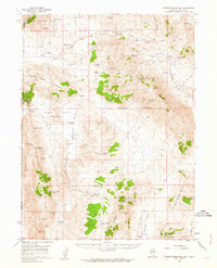
1957 Map of Dogskin Mountain
USGS Topo · Published 1963About this map
High desert terrain and vital water sources define this 1950s survey of the Nevada-California borderlands. Dominating the central landscape is Dogskin Mountain, surrounded by a network of basins including Red Rock Valley, Dry Valley, and the expansive Bedell Flat. The reliance on groundwater in this arid environment is evident from the numerous named springs and wells such as Renner Well (Artesian), McKissick Spring, and Settlemeyer Spring, many likely serving as critical watering points for early ranching or travel through the Winnemucca Valley.
Find a feature on this map
57 named features on this map. Tap any name to fly to it.
Don’t see what you’re looking for? This feature index may not catch every label — zoom into the map to look around manually.
Map Details
Editions of this 1957 Dogskin Mountain Map
3 editions found

Other maps of this area

1886 · Honey Lake
USGS Topo · 1:250,000

1886 · Granite Range
USGS Topo · 1:250,000

1890 · Sierraville
USGS Topo · 1:125,000

1891 · Honey Lake
USGS Topo · 1:250,000

1891 · Reno
USGS Topo · 1:125,000

1892 · Sierraville
USGS Topo · 1:125,000

1893 · Honey Lake
USGS Topo · 1:250,000

1893 · Reno
USGS Topo · 1:125,000

1894 · Granite Range
USGS Topo · 1:250,000

1894 · Sierraville
USGS Topo · 1:125,000