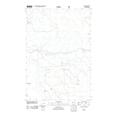
2011 Map of Dole
USGS Topo · Published 2011About this map
The settlement of Dole serves as the focal point for this 2011 survey of Clark County, situated in a landscape defined by the winding course of the East Fork Lewis River and its numerous tributaries. The area is characterized by steep timberlands and significant peaks such as Jack Mountain and Spotted Deer Mountain, which loom over the river valleys. Water management and recreation are central to the region, evidenced by the Yacolt Reservoir and its associated Yacolt Reservoir Dam in the northwest. Local geography is further marked by several outdoor recreation sites, including Tarbell Campground and Cold Creek Campground. The drainage pattern is intricate, with Rock Creek, Coyote Creek, and Big Creek carving through the terrain. This map captures the intersection of forestry access roads, like NE Sunset Falls Rd, and the natural landmarks that draw visitors to this corner of the Pacific Northwest, such as Horseshoe Falls.
Find a feature on this map
46 named features on this map. Tap any name to fly to it.
Don’t see what you’re looking for? This feature index may not catch every label — zoom into the map to look around manually.
Map Details
Editions of this 2011 Dole Map
This is the sole edition of this map. No revisions or reprints were ever made.
Other maps of this area

1918 · Troutdale
USGS Topo · 1:62,500

1934 · Troutdale
USGS Topo · 1:48,000

1940 · Lookout Mtn
USGS Topo · 1:62,500

1941 · Yacolt
USGS Topo · 1:62,500

1941 · Camas
USGS Topo · 1:62,500

1942 · Camas
USGS Topo · 1:62,500

1948 · Vancouver
USGS Topo · 1:250,000

1950 · Vancouver
USGS Topo · 1:250,000

1950 · Vancouver
USGS Topo · 1:250,000

1953 · Lookout Mtn
USGS Topo · 1:62,500