1973 Map of Doles
USGS Topo · Published 1975About this map
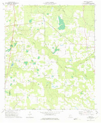
The agricultural lands of Doles and its surrounding countryside in Worth County are defined by a complex drainage system flowing toward Mercer Millpond and the Dougherty County border. This 1973 record reveals a rural community deeply anchored by its religious institutions, including Mt Horeb Ch, Charity Grove Ch, and Zion Grove Ch. The landscape is etched with the courses of Abrams Creek, Little Abrams Creek, and Red Oak Creek, which wind through low-lying areas. Unlike many neighboring regions, the area around Camp Osborn remains dominated by open terrain and timberland rather than dense urban development, showing the persistent rural character of southwest Georgia during the early 1970s. For those tracing family history, the multiple unnamed cemeteries and community landmarks provide essential geographic context for the era's local geography.
Find a feature on this map
16 named features on this map. Tap any name to fly to it.
Don’t see what you’re looking for? This feature index may not catch every label — zoom into the map to look around manually.
Map Details
Editions of this 1973 Doles Map
This is the sole edition of this map. No revisions or reprints were ever made.
Other maps of this area

1953 · Dothan
USGS Topo · 1:250,000

1953 · Waycross
USGS Topo · 1:250,000

1954 · Dothan
USGS Topo · 1:250,000

1955 · Dothan
USGS Topo · 1:250,000
1956 · Albany East
USGS Topo · 1:24,000

1956 · Sylvester
USGS Topo · 1:62,500

1956 · Albany
USGS Topo · 1:62,500
1956 · Leslie
USGS Topo · 1:62,500

1958 · Waycross
USGS Topo · 1:250,000
1972 · Cuffietown
USGS Topo · 1:24,000