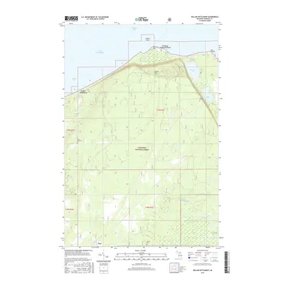
2017 Map of Dollar Settlement
USGS Topo · Published 2017About this map
Whitefish Bay and Lake Superior dominate the northern horizon of this coastal landscape, where the wooded expanses of the Hiawatha National Forest meet the shoreline. The settlement of Dollar Settlement is situated along the coast of Pendills Bay, providing a historical anchor for the area near the Dollar Settlement Cem. Inland, the terrain rises toward Mission Hill, where the Mission Hill Cem overlooks Spectacle Lake and Monocle Lake. To the south, the community of Raco sits near the headwaters of Little Waiska Cr and Br Orrs Cr. This 2017 survey shows a region defined by its maritime heritage and the transition from lakefront beaches like Westons Iroquois Beach to the dense forests of the Upper Peninsula interior.
Find a feature on this map
23 named features on this map. Tap any name to fly to it.
Don’t see what you’re looking for? This feature index may not catch every label — zoom into the map to look around manually.
Map Details
Editions of this 2017 Dollar Settlement Map
This is the sole edition of this map. No revisions or reprints were ever made.
Other maps of this area

1941 · Strongs
USGS Topo · 1:63,360

1941 · Brimley
USGS Topo · 1:63,360

1951 · Pendills Lake
USGS Topo · 1:24,000

1951 · Dollar Settlement
USGS Topo · 1:24,000

1951 · Sullivan Creek
USGS Topo · 1:24,000

1951 · Raco
USGS Topo · 1:24,000

1951 · Kinross
USGS Topo · 1:24,000

1951 · Brimley
USGS Topo · 1:62,500

1951 · Strongs
USGS Topo · 1:62,500

1951 · Brimley
USGS Topo · 1:24,000