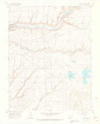
1965 Map of Dolores East
USGS Topo · Published 1967About this map
The Dolores River valley and the high terrain of Haycamp Mesa characterize this mid-1960s landscape in Montezuma County. The settlement of Dolores is positioned along the river in the northwest, featuring a local water tank and nearby kilns and a gravel pit that reflect the town's early utility and industry. Significant water management infrastructure is visible throughout the area, including the Puett Reservoir, Summit Reservoir, and an extensive network of irrigation channels like the Summit Ditch and Highline Ditch.
Find a feature on this map
34 named features on this map. Tap any name to fly to it.
Don’t see what you’re looking for? This feature index may not catch every label — zoom into the map to look around manually.
Map Details
Editions of this 1965 Dolores East Map
2 editions found
Other maps of this area

1956 · Cortez
USGS Topo · 1:250,000

1958 · Cortez
USGS Topo · 1:250,000

1959 · Cortez
USGS Topo · 1:250,000

1962 · Cortez
USGS Topo · 1:250,000

1963 · Stoner
USGS Topo · 1:24,000

1965 · Cortez
USGS Topo · 1:24,000

1965 · Dolores East
USGS Topo · 1:24,000

1965 · Dolores West
USGS Topo · 1:24,000
1965 · Millwood
USGS Topo · 1:24,000
1965 · Mancos
USGS Topo · 1:24,000