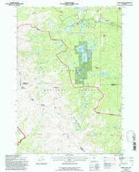
1993 Map of Dome Lake
USGS Topo · Published 1997About this map
High-altitude hydrology and mountain peaks define this section of the Bighorn National Forest, where the complex drainage of the West Fork Big Goose Creek feeds several significant alpine reservoirs. Built for early twentieth-century water management, the Dome Lake Reservoir and Dome Lake are central features, alongside smaller bodies like Sawmill Reservoir and the Weston Reservoir. The map illustrates the careful division of land along the Sheridan and Johnson County line, which cuts through the Cloud Peak Wilderness. Significant landmarks for navigation and local history include the prominent Saddle Mountain, Elk Peak, and Dome Rock. Traces of earlier human presence are visible near Preacher Rock and a legacy Gaging Station, illustrating the transition from resource development to wilderness conservation in the Wyoming high country.
Find a feature on this map
48 named features on this map. Tap any name to fly to it.
Don’t see what you’re looking for? This feature index may not catch every label — zoom into the map to look around manually.
Map Details
Editions of this 1993 Dome Lake Map
This is the sole edition of this map. No revisions or reprints were ever made.
Other maps of this area

1895 · Dayton
USGS Topo · 1:125,000

1899 · Cloud peak
USGS Topo · 1:125,000

1901 · Cloud Peak
USGS Topo · 1:125,000

1901 · Dayton
USGS Topo · 1:125,000

1955 · Sheridan
USGS Topo · 1:250,000

1958 · Sheridan
USGS Topo · 1:250,000

1960 · Shell Lake
USGS Topo · 1:24,000

1960 · Spanish Point
USGS Topo · 1:24,000

1962 · Sheridan
USGS Topo · 1:250,000

1964 · Walker Mountain
USGS Topo · 1:24,000