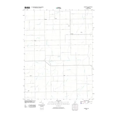
2010 Map of Domestic
USGS Topo · Published 2010About this map
Domestic and Perryville anchor this rural landscape in eastern Indiana, characterized by a complex drainage network developed for agriculture. The terrain is defined by numerous named man-made and natural waterways, including Loblolly Creek, Threemile Creek, and several engineering features like Bourne Williams Ditch and Egley Ditch. The survey highlights small, quiet crossroads settlements such as Phenix and Poling, which serve as focal points for the surrounding farmsteads. Genealogical interest is particularly strong here, with several well-preserved burial grounds including Alberson Cemetery and West Grove Cemetery near the western edge. In the southwest, the Twin Hills provides a rare point of elevation, overlooking Holmes Creek and Wall Run. The map demonstrates the persistence of traditional land divisions, with a grid of local roads like E Market St and numerous numbered county routes connecting these isolated communities and family landmarks.
Find a feature on this map
84 named features on this map. Tap any name to fly to it.
Don’t see what you’re looking for? This feature index may not catch every label — zoom into the map to look around manually.
Map Details
Editions of this 2010 Domestic Map
This is the sole edition of this map. No revisions or reprints were ever made.
Other maps of this area

1911 · Berne
USGS Topo · 1:48,000

1915 · Fort Recovery
USGS Topo · 1:48,000

1918 · Fort Recovery
USGS Topo · 1:62,500

1953 · Muncie
USGS Topo · 1:250,000

1956 · Muncie
USGS Topo · 1:250,000

1960 · Pennville
USGS Topo · 1:24,000

1960 · Blaine
USGS Topo · 1:24,000
1960 · Portland
USGS Topo · 1:24,000

1962 · Berne
USGS Topo · 1:24,000

1962 · Petroleum
USGS Topo · 1:24,000