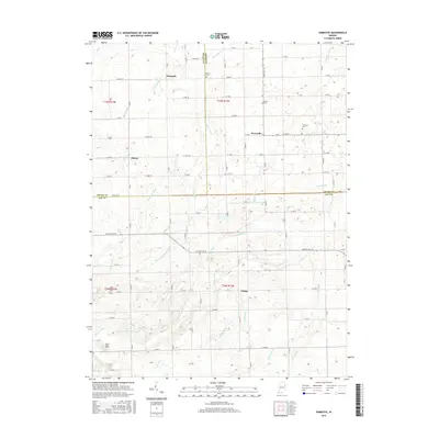
2016 Map of Domestic
USGS Topo · Published 2016About this map
The agricultural landscape of eastern Indiana at the border of Adams, Wells, and Jay Counties is defined by an intricate network of drainage systems such as Shoemaker Ditch, McAllister Ditch, and Shirk-Votaw Ditch. These waterways support the fertile plains surrounding the small settlements of Domestic, Perryville, and Poling. The terrain is generally level, though notable variations appear at Twin Hills in the southwest and near Loew Lake along W State Rd 18. For genealogists and local researchers, several burial grounds are preserved across the sections, including Alberson Cem, Brown Cem, Hartford Cem, and West Cem. The map illustrates the persistent 19th-century township-and-range grid, with local transit following routes like E Market St and Co Rd 1200 S, which delineate the county lines.
Find a feature on this map
59 named features on this map. Tap any name to fly to it.
Don’t see what you’re looking for? This feature index may not catch every label — zoom into the map to look around manually.
Map Details
Editions of this 2016 Domestic Map
This is the sole edition of this map. No revisions or reprints were ever made.
Other maps of this area

1911 · Berne
USGS Topo · 1:48,000

1915 · Fort Recovery
USGS Topo · 1:48,000

1918 · Fort Recovery
USGS Topo · 1:62,500

1953 · Muncie
USGS Topo · 1:250,000

1956 · Muncie
USGS Topo · 1:250,000

1960 · Pennville
USGS Topo · 1:24,000

1960 · Blaine
USGS Topo · 1:24,000
1960 · Portland
USGS Topo · 1:24,000

1962 · Berne
USGS Topo · 1:24,000

1962 · Petroleum
USGS Topo · 1:24,000