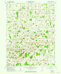
1962 Map of Domestic
USGS Topo · Published 1964About this map
Domestic and Perryville anchor this early 1960s landscape where the borders of Wells, Adams, and Jay Counties meet. The terrain is defined by a dense network of drainage infrastructure, such as Loblolly Creek, Votaw Ditch, and Downing Ditch, which converted the natural wetlands into productive farmland. Small rural hubs like Phenix and Poling are visible alongside local institutions including Township School and Union Chapel. Genealogical interest is found in the scattered rural burial grounds like Alberson Cemetery and Hartford Cemetery. The area’s economic activity is evidenced by several Oil Wells and a Gravel Pit near Twin Hills, illustrating the mix of agricultural and industrial land use characteristic of East Central Indiana during this era.
Find a feature on this map
65 named features on this map. Tap any name to fly to it.
Don’t see what you’re looking for? This feature index may not catch every label — zoom into the map to look around manually.
Map Details
Editions of this 1962 Domestic Map
This is the sole edition of this map. No revisions or reprints were ever made.
Other maps of this area

1911 · Berne
USGS Topo · 1:48,000

1915 · Fort Recovery
USGS Topo · 1:48,000

1918 · Fort Recovery
USGS Topo · 1:62,500

1953 · Muncie
USGS Topo · 1:250,000

1956 · Muncie
USGS Topo · 1:250,000

1960 · Pennville
USGS Topo · 1:24,000

1960 · Blaine
USGS Topo · 1:24,000
1960 · Portland
USGS Topo · 1:24,000

1962 · Berne
USGS Topo · 1:24,000

1962 · Petroleum
USGS Topo · 1:24,000