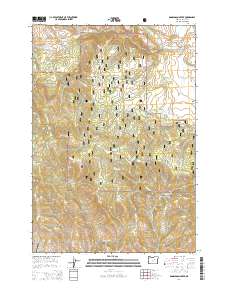
2014 Map of Donaldson Creek
USGS Topo · Published 2014About this map
Malhuer National Forest encompasses the vast majority of this high-elevation terrain in Grant County, where the landscape is defined by a dense network of drainage systems. The map captures the remote character of the region, anchored by the namesake Donaldson Creek and the small settlement of Fox Valley in the northeast. Water sources are critical landmarks in this environment, with named locations like Sagebrush Spring, Willow Spring, and Dolly Spring providing vital points of reference across the timbered slopes. The road network is sparse, featuring local routes such as Fox Valley Ln and CR 44, which navigate the steep topography between drainage basins. From the depths of Shop Gulch to the heights of the forest ridges, the survey details a landscape where natural topography and water rights dictate human activity and movement.
Find a feature on this map
26 named features on this map. Tap any name to fly to it.
Don’t see what you’re looking for? This feature index may not catch every label — zoom into the map to look around manually.
Map Details
Editions of this 2014 Donaldson Creek Map
This is the sole edition of this map. No revisions or reprints were ever made.
Other maps of this area

1940 · Mount Vernon
USGS Topo · 1:62,500

1940 · Aldrich Mtn.
USGS Topo · 1:62,500

1943 · Aldrich Mtn.
USGS Topo · 1:62,500

1943 · Mount Vernon
USGS Topo · 1:62,500

1949 · Long Creek
USGS Topo · 1:62,500

1951 · Long Creek
USGS Topo · 1:62,500

1951 · Courtrock
USGS Topo · 1:62,500

1955 · Canyon City
USGS Topo · 1:250,000

1959 · Canyon City
USGS Topo · 1:250,000
1972 · Aldrich Mountain North
USGS Topo · 1:24,000