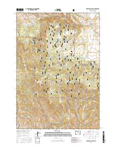
2017 Map of Donaldson Creek
USGS Topo · Published 2017About this map
Malheur National Forest dominates this landscape in northern Grant County, where the high-altitude terrain transitions into the pastoral opening of Fox Valley. The drainage network is complex, characterized by steep descents from high ridges into drainages like Donaldson Creek and Belshaw Cr. Historical land use is evidenced by the numerous named water sources critical for livestock and forest management, including Hinton Spring, Sagebrush Spring, and Dolly Spring. While much of the area remains underdeveloped, the presence of the Wiley Creek Airport and the logging routes such as Ridge Rd and Co Rd 88 indicate the region's reliance on both aviation and forest access for connectivity. The map also captures the varied topography of Shop Gulch and the winding course of Wildcat Cr, illustrating the rugged drainage patterns that define this section of the Oregon interior.
Find a feature on this map
28 named features on this map. Tap any name to fly to it.
Don’t see what you’re looking for? This feature index may not catch every label — zoom into the map to look around manually.
Map Details
Editions of this 2017 Donaldson Creek Map
This is the sole edition of this map. No revisions or reprints were ever made.
Other maps of this area

1940 · Mount Vernon
USGS Topo · 1:62,500

1940 · Aldrich Mtn.
USGS Topo · 1:62,500

1943 · Aldrich Mtn.
USGS Topo · 1:62,500

1943 · Mount Vernon
USGS Topo · 1:62,500

1949 · Long Creek
USGS Topo · 1:62,500

1951 · Long Creek
USGS Topo · 1:62,500

1951 · Courtrock
USGS Topo · 1:62,500

1955 · Canyon City
USGS Topo · 1:250,000

1959 · Canyon City
USGS Topo · 1:250,000
1972 · Aldrich Mountain North
USGS Topo · 1:24,000