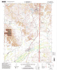
1996 Map of Dongola
USGS Topo · Published 1998About this map
The Cache River and its meandering tributaries dominate the southern Illinois landscape in this late-twentieth-century study of Union, Pulaski, and Alexander Counties. The village of Dongola sits at the northern edge, bordered by the American Legion Cem, while the settlement of Ullin is positioned where the river valley widens. The map reveals a rural economy shaped by natural resources and topographic shifts, including scattered quarries and the western edge of the Shawnee National Forest. Distinctive landmarks such as Rattlesnake Hill and Butter Ridge rise above the drainage networks of Mill Creek and Little Creek. For those researching local heritage, the map identifies established community centers like Mt Pisgah Ch and Beech Grove Ch, along with several small burial grounds including Union Cem and New Hope Cem, documenting the enduring settlement patterns of these southern Illinois communities.
Find a feature on this map
25 named features on this map. Tap any name to fly to it.
Don’t see what you’re looking for? This feature index may not catch every label — zoom into the map to look around manually.
Map Details
Editions of this 1996 Dongola Map
2 editions found
Other maps of this area

1920 · Jonesboro
USGS Topo · 1:62,500

1920 · Dongola
USGS Topo · 1:62,500

1923 · Dongola
USGS Topo · 1:62,500

1923 · Jonesboro
USGS Topo · 1:62,500

1931 · Cairo
USGS Topo · 1:62,500

1933 · Cairo
USGS Topo · 1:62,500

1934 · Thebes
USGS Topo · 1:62,500

1939 · Cairo
USGS Topo · 1:62,500

1939 · Thebes
USGS Topo · 1:62,500

1947 · Jonesboro
USGS Topo · 1:62,500