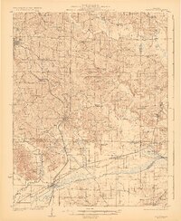
1923 Map of Dongola
USGS Topo · Published 1923About this map
Anna and the expansive grounds of the State Hospital anchor the northwestern corner of this Southern Illinois survey, which reveals a landscape deeply intertwined with the Cache River and its tributaries. The terrain transitions from the upland ridges near Mt Pleasant and Moscow down to the low-lying wetlands of the south, where the Illinois Central Railroad and Chicago and Eastern Illinois Railroad converge near Ullin and Joppa Junction. This rail-heavy corridor facilitated the movement of goods and people between agricultural settlements like Dongola and Wetaug.
Find a feature on this map
74 named features on this map. Tap any name to fly to it.
Don’t see what you’re looking for? This feature index may not catch every label — zoom into the map to look around manually.
Map Details
Editions of this 1923 Dongola Map
2 editions found
Other maps of this area

1918 · Vienna
USGS Topo · 1:62,500

1919 · Vienna
USGS Topo · 1:62,500

1920 · Jonesboro
USGS Topo · 1:62,500

1920 · Dongola
USGS Topo · 1:62,500

1922 · Carbondale
USGS Topo · 1:62,500

1923 · Dongola
USGS Topo · 1:62,500

1923 · Jonesboro
USGS Topo · 1:62,500

1924 · Alto Pass
USGS Topo · 1:62,500

1925 · Marion
USGS Topo · 1:62,500

1928 · La Center
USGS Topo · 1:62,500