
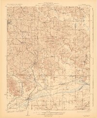
1923 Map of Dongola
USGS Topo · Published 1923About this map
The State Hospital anchors the northwestern corner of this Southern Illinois landscape, overlooking a dense network of early 20th-century rural infrastructure. Centered on the Third Principal Meridian, the region is defined by the swampy lowlands of the Cache River and its numerous tributaries like Cypress Creek and Mill Creek. The settlement pattern follows the rail lines, with Dongola, Wetaug, and Ullin established along the Illinois Central, while Chicago and Eastern Illinois tracks cut across the southern marshes toward Perks. This survey reveals an era before consolidated districts, where the countryside is dotted with dozens of neighborhood schoolhouses and community churches. From the Sivia School in the north to the New Hope School near the southern boundary, these sites, often named for local families like Barringer or Meisenheimer, offer specific coordinates for genealogical research in Union and Pulaski Counties.
Find a feature on this map
67 named features on this map. Tap any name to fly to it.
Don’t see what you’re looking for? This feature index may not catch every label — zoom into the map to look around manually.
Map Details
Editions of this 1923 Dongola Map
2 editions found
Other maps of this area

1918 · Vienna
USGS Topo · 1:62,500

1919 · Vienna
USGS Topo · 1:62,500

1920 · Jonesboro
USGS Topo · 1:62,500

1920 · Dongola
USGS Topo · 1:62,500

1922 · Carbondale
USGS Topo · 1:62,500

1923 · Jonesboro
USGS Topo · 1:62,500

1924 · Alto Pass
USGS Topo · 1:62,500

1925 · Marion
USGS Topo · 1:62,500

1928 · La Center
USGS Topo · 1:62,500

1931 · Cairo
USGS Topo · 1:62,500