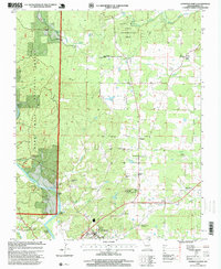
1997 Map of Doniphan North
USGS Topo · Published 1999About this map
The Current River flows through the southwest corner of this Ozark landscape, where the town of Doniphan serves as a focal point for the surrounding rural communities. During the late twentieth century, this area maintained a mix of agricultural clearings and dense forest cover within the Mark Twain National Forest. The map documents a high density of small rural institutions, including the Fairview School and numerous family or community burial grounds such as Elizabeth Cemetery and the Mc Gee-Payne Cemetery.
Find a feature on this map
51 named features on this map. Tap any name to fly to it.
Don’t see what you’re looking for? This feature index may not catch every label — zoom into the map to look around manually.
Map Details
Editions of this 1997 Doniphan North Map
This is the sole edition of this map. No revisions or reprints were ever made.
Other maps of this area

1934 · Williamsville
USGS Topo · 1:48,000

1935 · Acorn
USGS Topo · 1:62,500

1939 · Doniphan
USGS Topo · 1:62,500

1940 · Williamsville
USGS Topo · 1:62,500

1940 · Naylor
USGS Topo · 1:62,500

1944 · Naylor
USGS Topo · 1:62,500

1944 · Grandin
USGS Topo · 1:62,500

1945 · Doniphan
USGS Topo · 1:62,500

1946 · Grandin
USGS Topo · 1:62,500

1957 · Poplar Bluff
USGS Topo · 1:250,000