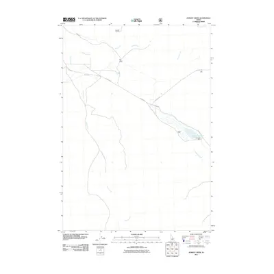
2011 Map of Donkey Creek
USGS Topo · Published 2011About this map
Summit Ranch stands as a central landmark in this high-altitude valley of Custer County, Idaho, where water management is the primary driver of the local landscape. The drainage of Donkey Creek and Summit Creek defines the basin, supported by the engineering of the Summit Dam and its accompanying Summit Reservoir. These features suggest a ranching and agricultural economy dependent on seasonal snowmelt and spring-fed sources like Graves Spring. High mountain drainages, including Bear Creek and Snowslide Creek, descend from the surrounding peaks toward the valley floor. Transportation is limited to functional routes such as Goldburg Rd and Pahsimeroi Rd, which connect the remote ranching outposts and provide access through the significant terrain features of Big Gulch and Cooney Canyon.
Find a feature on this map
17 named features on this map. Tap any name to fly to it.
Don’t see what you’re looking for? This feature index may not catch every label — zoom into the map to look around manually.
Map Details
Editions of this 2011 Donkey Creek Map
This is the sole edition of this map. No revisions or reprints were ever made.
Other maps of this area

1935 · Borah Peak
USGS Topo · 1:125,000

1938 · Borah Peak
USGS Topo · 1:125,000

1955 · Dubois
USGS Topo · 1:250,000

1956 · Donkey Hills
USGS Topo · 1:62,500

1957 · Gilmore
USGS Topo · 1:62,500

1957 · Hawley Mountain
USGS Topo · 1:62,500

1958 · Dubois
USGS Topo · 1:250,000
1967 · Burnt Creek
USGS Topo · 1:24,000
1967 · Short Creek
USGS Topo · 1:24,000
1987 · Red Hills
USGS Topo · 1:24,000