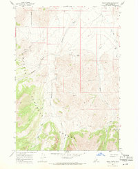
1967 Map of Burnt Creek
USGS Topo · Published 1971About this map
The Challis National Forest dominates this Idaho landscape, where high-altitude drainage systems converge within the Lost River Range. Surveyed in the late 1960s, the terrain is defined by the Pahsimeroi River and its numerous tributaries, including Mahogany Creek and the converging West Fork and East Fork of Burnt Creek. Human presence is minimal and functional, marked by a Water Tank, a Corral, and a network of Jeep Trails and Pack Trails used for backcountry access. Natural water sources are scattered throughout the quadrangle, notably Poison Springs and Mud Spring. The elevation reaches its peak near Burnt Creek Lake in the southeast corner, illustrating the transition from river valley floors to the protected forest interior.
Find a feature on this map
18 named features on this map. Tap any name to fly to it.
Don’t see what you’re looking for? This feature index may not catch every label — zoom into the map to look around manually.
Map Details
Editions of this 1967 Burnt Creek Map
2 editions found
Other maps of this area

1935 · Borah Peak
USGS Topo · 1:125,000

1938 · Borah Peak
USGS Topo · 1:125,000

1955 · Dubois
USGS Topo · 1:250,000

1956 · Donkey Hills
USGS Topo · 1:62,500

1956 · Doublespring
USGS Topo · 1:62,500

1958 · Dubois
USGS Topo · 1:250,000
1962 · Leatherman Peak
USGS Topo · 1:24,000
1967 · Massacre Mtn
USGS Topo · 1:24,000
1967 · Elkhorn Creek
USGS Topo · 1:24,000
1967 · Borah Peak
USGS Topo · 1:24,000