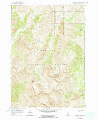
1967 Map of Massacre Mtn
USGS Topo · Published 1970About this map
Massacre Mountain dominates the eastern skyline in this high-altitude corner of the Lost River Range, where the landscape is defined by its dramatic elevation changes and alpine water systems. In the late 1960s, this portion of the Challis National Forest remained largely inaccessible to vehicles, relying instead on a network of pack trails and unmaintained trails to connect remote peaks and glacial basins. The map reveals a complex hydrology where steep drainages like Hell Canyon and Long Lost Creek carry seasonal runoff from high-mountain catchments. For researchers, the presence of numerous small alpine bodies such as Swauger Lakes, Copper Lake, Shadow Lakes, and Nolan Lake provides a clear view of the mountain topography and drainage patterns before modern recreational developments altered the backcountry character of Custer County.
Find a feature on this map
22 named features on this map. Tap any name to fly to it.
Don’t see what you’re looking for? This feature index may not catch every label — zoom into the map to look around manually.
Map Details
Editions of this 1967 Massacre Mtn Map
2 editions found
Other maps of this area

1935 · MacKay
USGS Topo · 1:96,000

1935 · Borah Peak
USGS Topo · 1:125,000

1938 · Borah Peak
USGS Topo · 1:125,000

1940 · Mackay
USGS Topo · 1:62,500

1955 · Dubois
USGS Topo · 1:250,000

1955 · Idaho Falls
USGS Topo · 1:250,000

1957 · Hawley Mountain
USGS Topo · 1:62,500

1958 · Dubois
USGS Topo · 1:250,000

1958 · Idaho Falls
USGS Topo · 1:250,000

1960 · Mackay
USGS Topo · 1:62,500