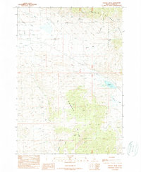
1989 Map of Donkey Creek
USGS Topo · Published 1989About this map
Challis National Forest land dominates this high-altitude Custer County landscape, where the Donkey Hills rise above a complex network of alpine drainages. The area is defined by its water resources, including the Summit Reservoir and numerous unnamed Spring sites that feed the Goldburg Creek and Donkey Creek systems. A man-made Ditch in the northwest corner suggests early irrigation or mining efforts to divert water across the Hillside terrain. Topographic details highlight the steep-walled canyons of Snowslide Gulch and Big Gulch, illustrating the erosive forces at work in this part of Idaho. This provisional survey captures the region's character as a resource-rich environment before later 20th-century developments, showing the primitive trail and improved road network used to navigate the high country.
Find a feature on this map
19 named features on this map. Tap any name to fly to it.
Don’t see what you’re looking for? This feature index may not catch every label — zoom into the map to look around manually.
Map Details
Editions of this 1989 Donkey Creek Map
This is the sole edition of this map. No revisions or reprints were ever made.
Other maps of this area

1935 · Borah Peak
USGS Topo · 1:125,000

1938 · Borah Peak
USGS Topo · 1:125,000

1955 · Dubois
USGS Topo · 1:250,000

1956 · Donkey Hills
USGS Topo · 1:62,500

1957 · Gilmore
USGS Topo · 1:62,500

1957 · Hawley Mountain
USGS Topo · 1:62,500

1958 · Dubois
USGS Topo · 1:250,000
1967 · Burnt Creek
USGS Topo · 1:24,000
1967 · Short Creek
USGS Topo · 1:24,000
1987 · Red Hills
USGS Topo · 1:24,000