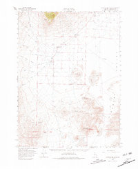
1966 Map of Donna Schee Peak
USGS Topo · Published 1981About this map
The high desert landscape of Desert Valley in the mid-1960s is defined by its sparse but vital water sources and ranching outposts. Anchored by the prominence of Donna Schee Peak and the volcanic-profile of Schoolhouse Butte, this region of Humboldt County relies on a network of remote holdings like the Alexander Ranch, Willow Creek Ranch, and Trout Creek Ranch. The survival of these sites is supported by engineered irrigation and natural flows, seen in the Big Cedar Creek Ditch and Bull Creek Ditch, which redirect snowmelt from the Jackson Mts toward the lowlands.
Find a feature on this map
39 named features on this map. Tap any name to fly to it.
Don’t see what you’re looking for? This feature index may not catch every label — zoom into the map to look around manually.
Map Details
Editions of this 1966 Donna Schee Peak Map
2 editions found

Other maps of this area

1886 · Disaster
USGS Topo · 1:250,000

1893 · Disaster
USGS Topo · 1:250,000

1931 · Lovelock
USGS Topo · 1:250,000

1935 · Lovelock
USGS Topo · 1:250,000

1954 · Vya
USGS Topo · 1:250,000

1955 · Lovelock
USGS Topo · 1:250,000

1958 · Vya
USGS Topo · 1:250,000

1959 · Lovelock
USGS Topo · 1:250,000

1961 · Bottle Creek
USGS Topo · 1:62,500

1962 · Vya
USGS Topo · 1:250,000