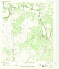
1967 Map of Doole
USGS Topo · Published 1969About this map
The Colorado River snakes through the heart of this landscape, carving dramatic geological features like Horseshoe Bend and Brady Bend as it follows the shared boundary of Coleman, Concho, and McCulloch counties. The settlement of Stacy sits near the river's northern sweep, while the small community of Doole anchors the southwestern plains. This territory is defined by a dense network of seasonal drainages, including Bois d'Arc Creek and Salt Creek, which cut through the limestone terrain toward the river. For genealogists, the map preserves the location of a local Cem near Stacy and several industrial markers such as a Well and multiple Gravel Pit sites. The elevation rise at Wallooppe and the course of Panther Creek provide context for the historical land use in this section of Central Texas during the late 1960s.
Find a feature on this map
20 named features on this map. Tap any name to fly to it.
Don’t see what you’re looking for? This feature index may not catch every label — zoom into the map to look around manually.
Map Details
Editions of this 1967 Doole Map
This is the sole edition of this map. No revisions or reprints were ever made.
Other maps of this area

1887 · Coleman
USGS Topo · 1:125,000

1889 · Coleman
USGS Topo · 1:125,000

1892 · Eden
USGS Topo · 1:125,000

1892 · Ballinger
USGS Topo · 1:125,000

1894 · Brady
USGS Topo · 1:125,000

1896 · Eden
USGS Topo · 1:125,000

1924 · Eden 1-a
USGS Topo · 1:48,000

1925 · Brady 2-b
USGS Topo · 1:48,000

1925 · Ballinger 4-c
USGS Topo · 1:48,000

1928 · Waldrip
USGS Topo · 1:62,500