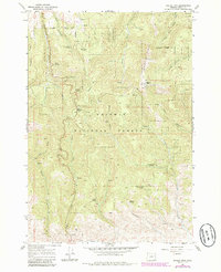
1967 Map of Dooley Mtn
USGS Topo · Published 1986About this map
Whitman National Forest land defines this portion of the Blue Mountains, where high-elevation landmarks like Bald Ridge and Dooley Mtn overlook a complex network of canyons and gulches. The terrain is notably water-rich for the region, marked by numerous named water sources such as Moonshine Spring, Trail Creek Spring, and Rooster Rock Spring. These natural points often served as critical stops for early travelers and forest workers moving through the steep grades between the drainage systems.
Find a feature on this map
30 named features on this map. Tap any name to fly to it.
Don’t see what you’re looking for? This feature index may not catch every label — zoom into the map to look around manually.
Map Details
Editions of this 1967 Dooley Mtn Map
2 editions found
Other maps of this area

1901 · Baker City
USGS Topo · 1:125,000

1955 · Baker
USGS Topo · 1:250,000

1959 · Baker
USGS Topo · 1:250,000

1964 · Bridgeport
USGS Topo · 1:62,500

1964 · Ironside
USGS Topo · 1:62,500

1967 · Encina
USGS Topo · 1:24,000

1967 · French Gulch
USGS Topo · 1:24,000

1967 · Dooley Mtn
USGS Topo · 1:24,000

1967 · Blue Canyon
USGS Topo · 1:24,000
1967 · Bowen Valley
USGS Topo · 1:24,000