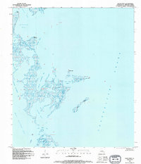
1994 Map of Door Point
USGS Topo · Published 1995About this map
The low-lying coastal marshes and estuarine waters of Chino Bay and West Karako Bay dominate this 1994 chart of the St. Bernard Parish coastline. This landscape is a complex labyrinth of tidal inlets and eroding landmasses, where the distinction between land and water is constantly shifting. Notable features include the isolated Brush Island and the protective spit of Door Point, which separates Door Point Lagoon from the open expanse of Chandeleur Sound. The presence of labels like Murder Bayou and Deep Water Pass highlights the navigation-critical nature of these waterways for local fishing and maritime operations. The map reflects a period of significant environmental transition, documenting the fragile state of these barrier features and interior bayous before further coastal changes. Navigational landmarks such as Pelican Point and Point Chevrette serve as essential reference points in a terrain where traditional roads and trails are entirely absent.
Find a feature on this map
17 named features on this map. Tap any name to fly to it.
Don’t see what you’re looking for? This feature index may not catch every label — zoom into the map to look around manually.
Map Details
Editions of this 1994 Door Point Map
This is the sole edition of this map. No revisions or reprints were ever made.
Other maps of this area

1893 · Cat Island
USGS Topo · 1:62,500

1893 · Chandeleur
USGS Topo · 1:62,500

1893 · Toulme
USGS Topo · 1:62,500

1895 · Bodreau
USGS Topo · 1:62,500

1935 · Mitchell Keys
USGS Topo · 1:31,680

1946 · Oak Mound Bayou
USGS Topo · 1:31,680

1946 · Isle Au Pitre
USGS Topo · 1:31,680
1949 · Drum Bay
USGS Topo · 1:31,680
1949 · Door Point
USGS Topo · 1:31,680

1951 · Cat Island
USGS Topo · 1:24,000