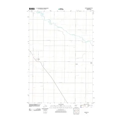
2010 Map of Doran
USGS Topo · Published 2010About this map
The Otter Tail River winds through the northern portion of this Wilkin County landscape, defining the topography of an otherwise orderly agricultural grid. The small settlement of Doran serves as the local hub, situated at a key intersection of regional thoroughfares. Beyond the town center, the map reveals a rural landscape dominated by township roads like Twp Hwy 140 and T-143. Genealogists and local historians will find significant value in the preservation of two burial sites: the Sticklestad Cemetery and the Old Vikku Lutheran Cemetery, which anchor the history of early Lutheran settlement in the region. The map’s thorough documentation of the road network, including County Hwy-159 and County Hwy-17, illustrates the connection between these remote homesteads and the larger river valley economy.
Find a feature on this map
24 named features on this map. Tap any name to fly to it.
Don’t see what you’re looking for? This feature index may not catch every label — zoom into the map to look around manually.
Map Details
Editions of this 2010 Doran Map
This is the sole edition of this map. No revisions or reprints were ever made.
Other maps of this area

1904 · Wahpeton
USGS Topo · 1:125,000

1919 · Rothsay
USGS Topo · 1:62,500

1951 · Rothsay
USGS Topo · 1:62,500

1951 · Campbell
USGS Topo · 1:62,500

1953 · Fargo
USGS Topo · 1:250,000

1956 · Fargo
USGS Topo · 1:250,000

1964 · Wahpeton
USGS Topo · 1:24,000
1973 · South of Wahpeton
USGS Topo · 1:24,000
1973 · Fairmount
USGS Topo · 1:24,000
1981 · Campbell
USGS Topo · 1:24,000