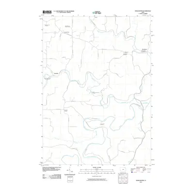
2010 Map of Dorchester
USGS Topo · Published 2010About this map
Waterloo Creek and the Upper Iowa River define the winding drainage patterns of this northeastern Iowa landscape, where agricultural plateaus are interrupted by deep river valleys. The small settlement of Dorchester serves as a focal point near the eastern edge, anchored by the Dorchester Post Office. The area is notably dense with small family and parish burial grounds, including Swenson Farm Cemetery, Waterloo Ridge Cemetery, and the O'Hare Place Cemetery, which offer significant data for genealogical research. To the west, the hamlet of Quandahl sits near the North Bear Creek Access Area, reflecting the region's mix of remote farmsteads and conservation lands. The presence of Camp Tahigwa along Bear Creek further illustrates how the terrain has been utilized for both rural residence and organized recreation.
Find a feature on this map
52 named features on this map. Tap any name to fly to it.
Don’t see what you’re looking for? This feature index may not catch every label — zoom into the map to look around manually.
Map Details
Editions of this 2010 Dorchester Map
This is the sole edition of this map. No revisions or reprints were ever made.
Other maps of this area

1903 · Waukon
USGS Topo · 1:125,000

1906 · Decorah
USGS Topo · 1:125,000

1956 · Brownsville
USGS Topo · 1:62,500

1958 · La Crosse
USGS Topo · 1:250,000

1961 · La Crosse
USGS Topo · 1:250,000

1965 · La Crosse
USGS Topo · 1:250,000

1965 · Wilmington
USGS Topo · 1:24,000

1965 · Spring Grove
USGS Topo · 1:24,000

1968 · Waukon
USGS Topo · 1:24,000
1968 · Waukon NW
USGS Topo · 1:24,000