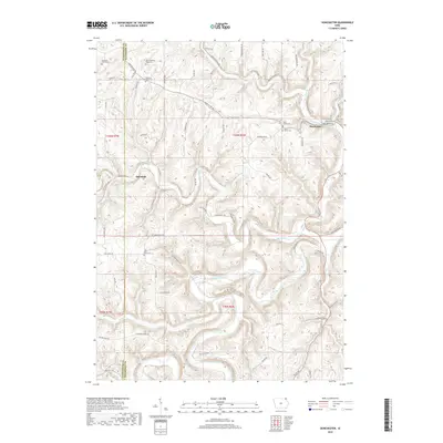
2018 Map of Dorchester
USGS Topo · Published 2018About this map
The Upper Iowa River carves a deep path through the northeast corner of Iowa, where the border of Winneshiek Co and Allamakee Co meets. This 2018 survey reveals a landscape defined by steep ridges and winding valleys, anchored by the small settlement of Dorchester in the north and the village of Quandahl to the west. The area is notable for its concentration of family and community burial grounds, including Swenson Farm Cem, Waterloo Ridge Cem, and the O'Hare Place Cem, offering significant data points for genealogists tracing the legacy of the West Waterloo Ridge area. Tributaries like Waterloo Cr and Paint Cr cut through the limestone-influenced terrain, while the presencia of Tahigwa Camp suggests the region's continued importance for recreation and community gathering amidst the valley slopes.
Find a feature on this map
71 named features on this map. Tap any name to fly to it.
Don’t see what you’re looking for? This feature index may not catch every label — zoom into the map to look around manually.
Map Details
Editions of this 2018 Dorchester Map
This is the sole edition of this map. No revisions or reprints were ever made.
Other maps of this area

1903 · Waukon
USGS Topo · 1:125,000

1906 · Decorah
USGS Topo · 1:125,000

1956 · Brownsville
USGS Topo · 1:62,500

1958 · La Crosse
USGS Topo · 1:250,000

1961 · La Crosse
USGS Topo · 1:250,000

1965 · La Crosse
USGS Topo · 1:250,000

1965 · Wilmington
USGS Topo · 1:24,000

1965 · Spring Grove
USGS Topo · 1:24,000

1968 · Waukon
USGS Topo · 1:24,000
1968 · Waukon NW
USGS Topo · 1:24,000