
1956 Map of Dorrance
USGS Topo · Published 1958About this map
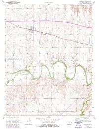
Dorrance serves as the primary population center on this mid-century survey of the Kansas plains, situated along the vital transport corridor of the Union Pacific railroad. The town's grid and surrounding rural landscape reflect the organized development of Russell County, where sections are clearly marked for agriculture and local services. To the south, the Smoky Hill River meanders in tight, dramatic oxbows, carved deeply into the terrain alongside Beaver Creek. This physical geography shaped the placement of early community landmarks, including several rural burial grounds like St Joseph Cem, Schreiner Cem, and Immanuel Cem. The presence of the Cliff Sch and a scattered Oil Well near the southern margin indicates a dual economy of education and resource extraction typical of the region during the 1950s.
Find a feature on this map
12 named features on this map. Tap any name to fly to it.
Don’t see what you’re looking for? This feature index may not catch every label — zoom into the map to look around manually.
Map Details
Editions of this 1956 Dorrance Map
2 editions found
Other maps of this area

1894 · Ellsworth
USGS Topo · 1:125,000

1896 · Russell
USGS Topo · 1:125,000

1955 · Great Bend
USGS Topo · 1:250,000

1956 · Wilson
USGS Topo · 1:24,000

1956 · Dorrance SW
USGS Topo · 1:24,000

1957 · Great Bend
USGS Topo · 1:250,000

1958 · Great Bend
USGS Topo · 1:250,000
1964 · Wilson NW
USGS Topo · 1:24,000
1964 · Holyrood NW
USGS Topo · 1:24,000
1967 · Dorrance NW
USGS Topo · 1:24,000