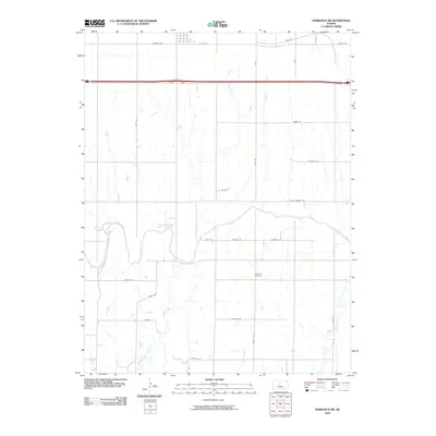
2009 Map of Dorrance SW
USGS Topo · Published 2009About this map
Bunker Hill occupies the northern edge of this Russell County landscape, where the southern reaches of the settlement meet the open prairie. The terrain is defined by the winding course of the Smoky Hill River, which cuts across the central portion of the map. This waterway is joined by several significant tributaries, including Goose Creek and Beaver Creek, creating a drainage pattern that has historically influenced the placement of rural roads and homesteads. The southern part of the survey captures the small locality of Waters and the Hyde Park Cemetery, a key site for local genealogical research.
Find a feature on this map
27 named features on this map. Tap any name to fly to it.
Don’t see what you’re looking for? This feature index may not catch every label — zoom into the map to look around manually.
Map Details
Editions of this 2009 Dorrance SW Map
This is the sole edition of this map. No revisions or reprints were ever made.
Other maps of this area

1896 · Russell
USGS Topo · 1:125,000

1955 · Great Bend
USGS Topo · 1:250,000

1956 · Dorrance
USGS Topo · 1:24,000

1956 · Dorrance SW
USGS Topo · 1:24,000

1957 · Great Bend
USGS Topo · 1:250,000

1958 · Great Bend
USGS Topo · 1:250,000

1961 · Homer
USGS Topo · 1:24,000
1967 · Dorrance NW
USGS Topo · 1:24,000

1967 · Russell
USGS Topo · 1:24,000
1967 · Dorrance NE
USGS Topo · 1:24,000