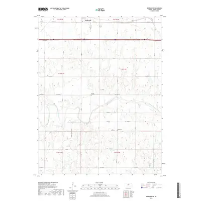
2018 Map of Dorrance SW
USGS Topo · Published 2018About this map
Bunker Hill sits at the northern edge of this Russell County landscape, a central point for the surrounding agricultural section lines that define the region's development. The map follows the meandering path of the Smoky Hill River as it cuts eastward across the central terrain, creating a natural break in the geometric grid of rural roads like Pioneer East Rd and Fairfield Rd. The presence of Blooming Grove Cem and Hyde Park Cem provides specific points of interest for genealogical research, marking the community's established history within these rural townships. Local hydrology is further defined by tributaries such as Goose Cr and Beaver Cr, which feed into the primary river valley. The corridor is anchored by major transit routes, including Old US Hwy 40, reflecting the long-standing transportation patterns that have connected these Kansas settlements since the early twentieth century.
Find a feature on this map
37 named features on this map. Tap any name to fly to it.
Don’t see what you’re looking for? This feature index may not catch every label — zoom into the map to look around manually.
Map Details
Editions of this 2018 Dorrance SW Map
This is the sole edition of this map. No revisions or reprints were ever made.
Other maps of this area

1896 · Russell
USGS Topo · 1:125,000

1955 · Great Bend
USGS Topo · 1:250,000

1956 · Dorrance
USGS Topo · 1:24,000

1956 · Dorrance SW
USGS Topo · 1:24,000

1957 · Great Bend
USGS Topo · 1:250,000

1958 · Great Bend
USGS Topo · 1:250,000

1961 · Homer
USGS Topo · 1:24,000
1967 · Dorrance NW
USGS Topo · 1:24,000

1967 · Russell
USGS Topo · 1:24,000
1967 · Dorrance NE
USGS Topo · 1:24,000