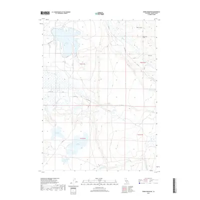
2018 Map of Dorris Reservoir
USGS Topo · Published 2018About this map
Dorris Reservoir dominates this high-altitude landscape in northeastern California, where complex water management systems define the terrain. The map reveals a network of engineered water bodies, including Payne Reservoir, Dannhauser Reservoir, and French Reservoir, which are interconnected by drainages such as Pine Cr and Fitzhugh Cr. This arrangement suggests a region heavily reliant on seasonal water storage for local use. The topography is further characterized by the deep indentations of Renfro Canyon and White Horse Canyon to the north. A grid of county roads, such as Parker Creek Rd and Pine Creek Blvd, provides access to these water sources and the varied elevations of Hog Gulch and the surrounding Modoc County highlands.
Find a feature on this map
31 named features on this map. Tap any name to fly to it.
Don’t see what you’re looking for? This feature index may not catch every label — zoom into the map to look around manually.
Map Details
Editions of this 2018 Dorris Reservoir Map
This is the sole edition of this map. No revisions or reprints were ever made.
Other maps of this area
1886 · Alturas
USGS Topo · 1:250,000
1892 · Alturas
USGS Topo · 1:250,000
1954 · Alturas
USGS Topo · 1:250,000
1958 · Alturas
USGS Topo · 1:250,000
1961 · Alturas
USGS Topo · 1:62,500
1962 · Alturas
USGS Topo · 1:250,000
1962 · Davis Creek
USGS Topo · 1:62,500
1962 · Big Sage Reservoir
USGS Topo · 1:62,500
1963 · Little Juniper Reservoir
USGS Topo · 1:24,000
1963 · Shields Creek
USGS Topo · 1:24,000