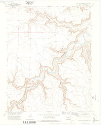
1972 Map of Doss Canyon North
USGS Topo · Published 1975About this map
The Purgatoire River carves a deep, winding course through the high plains of Las Animas County in this 1970s landscape. This topographical study captures the complex network of drainage systems feeding into the river, characterized by prominent features like Doss Canyon and Lockwood Canyon. The terrain is defined by its vertical relief, where narrow canyons such as Little Pine Canyon and Dead Horse Canyon intersect with broader arroyos like Taylor Arroyo. Human presence is sparse, marked primarily by a Landing Strip and the Waller landmark near the eastern edge. A spiderweb of Jeep Trails provides the primary means of navigation through the uplands between Henry George Canyon and Alejandro Canyon, illustrating the remote and specialized transit required for land management or exploration in this part of Colorado.
Find a feature on this map
15 named features on this map. Tap any name to fly to it.
Don’t see what you’re looking for? This feature index may not catch every label — zoom into the map to look around manually.
Map Details
Editions of this 1972 Doss Canyon North Map
4 editions found
Other maps of this area

1891 · Timpas
USGS Topo · 1:125,000

1891 · Mesa De Maya
USGS Topo · 1:125,000

1893 · Mesa de Maya
USGS Topo · 1:125,000

1894 · Timpas
USGS Topo · 1:125,000

1955 · La Junta
USGS Topo · 1:250,000

1958 · La Junta
USGS Topo · 1:250,000

1968 · La Junta
USGS Topo · 1:250,000

1972 · Johnson Canyon
USGS Topo · 1:24,000

1972 · Doss Canyon North
USGS Topo · 1:24,000

1972 · Doss Canyon South
USGS Topo · 1:24,000