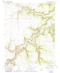
1972 Map of Doss Canyon North
USGS Topo · Published 1985About this map
The Purgatoire River carves a winding path through this corner of Las Animas County, creating a complex network of side canyons that define the local geography. These deep drainage systems, including Doss Canyon and Lockwood Canyon, reveal a landscape shaped by intermittent water and erosion. The presence of several family or place-named features like Taylor Canyon and Alejandro Canyon suggests a history of ranching or early land claims tied to these specific riparian corridors.
Find a feature on this map
12 named features on this map. Tap any name to fly to it.
Don’t see what you’re looking for? This feature index may not catch every label — zoom into the map to look around manually.
Map Details
Editions of this 1972 Doss Canyon North Map
4 editions found
Other maps of this area

1891 · Timpas
USGS Topo · 1:125,000

1891 · Mesa De Maya
USGS Topo · 1:125,000

1893 · Mesa de Maya
USGS Topo · 1:125,000

1894 · Timpas
USGS Topo · 1:125,000

1955 · La Junta
USGS Topo · 1:250,000

1958 · La Junta
USGS Topo · 1:250,000

1968 · La Junta
USGS Topo · 1:250,000

1972 · Johnson Canyon
USGS Topo · 1:24,000

1972 · Doss Canyon North
USGS Topo · 1:24,000

1972 · Doss Canyon South
USGS Topo · 1:24,000