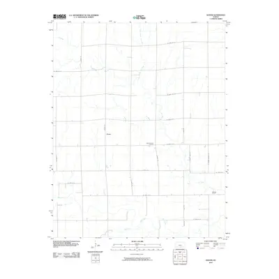
2010 Map of Doster
USGS Topo · Published 2010About this map
Doster sits as a quiet focal point in this southern Kansas landscape, where the geometry of section-line roads meets the winding courses of local waterways. The map documents a predominantly agricultural region defined by the drainage of Fall Creek and Bluff Creek, which carve subtle paths across the plains. A significant cultural landmark is the Cesko Slovensky Cemetery, a site reflecting the heritage of the early settlers who established roots in this portion of Sumner County. Industry is represented toward the eastern edge by the Fall Creek Oil Field, signaling the persistence of resource extraction in the modern era. The grid of rural routes, including S Dixon Rd and S Milan Rd, connects these disparate points of local history and commerce, providing a clear view of the area's twentieth and early twenty-first-century infrastructure.
Find a feature on this map
25 named features on this map. Tap any name to fly to it.
Don’t see what you’re looking for? This feature index may not catch every label — zoom into the map to look around manually.
Map Details
Editions of this 2010 Doster Map
This is the sole edition of this map. No revisions or reprints were ever made.
Other maps of this area

1889 · Caldwell
USGS Topo · 1:125,000

1893 · Caldwell
USGS Topo · 1:125,000

1897 · Caldwell
USGS Topo · 1:125,000

1955 · Wichita
USGS Topo · 1:250,000

1955 · Enid
USGS Topo · 1:250,000

1958 · Enid
USGS Topo · 1:250,000

1958 · Wichita
USGS Topo · 1:250,000

1968 · Renfrow
USGS Topo · 1:24,000
1968 · Medford NE
USGS Topo · 1:24,000
1968 · Wakita NE
USGS Topo · 1:24,000