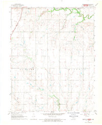
1968 Map of Medford NE
USGS Topo · Published 1970About this map
Caldwell sits at the northern edge of this late-1960s landscape, where the Chicago and Rock Island Pacific railroad cuts across the Kansas-Oklahoma border. The map documents a transition between early mid-century recreational landmarks and industrial activity, featuring the Drive-in Theater and Caldwell Golf Course alongside multiple Shale Pits and the Southeast Renfrow Oil Field. The terrain is defined by the winding paths of Bluff Creek and Deer Creek, which flow through the townships of Fairview and Bluff. Local genealogy and community markers are well-preserved in the placement of North Star Ch, Spring Creek Cem, and Williams Cem. Detailed fence and field lines, interpreted from 1965 aerial photography, provide a precise record of rural property boundaries and agricultural patterns during this era.
Find a feature on this map
21 named features on this map. Tap any name to fly to it.
Don’t see what you’re looking for? This feature index may not catch every label — zoom into the map to look around manually.
Map Details
Editions of this 1968 Medford NE Map
2 editions found
Other maps of this area

1889 · Caldwell
USGS Topo · 1:125,000

1890 · Wellington
USGS Topo · 1:125,000

1893 · Caldwell
USGS Topo · 1:125,000

1897 · Caldwell
USGS Topo · 1:125,000

1955 · Wichita
USGS Topo · 1:250,000

1955 · Enid
USGS Topo · 1:250,000

1958 · Enid
USGS Topo · 1:250,000

1958 · Wichita
USGS Topo · 1:250,000

1965 · South Haven
USGS Topo · 1:24,000

1968 · Deer Creek
USGS Topo · 1:24,000