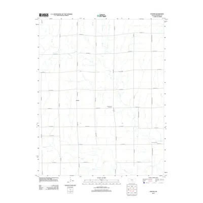
2012 Map of Doster
USGS Topo · Published 2012About this map
Doster sits at the heart of this Sumner County agricultural landscape, defined by a rigid grid of country roads and winding prairie streams. The terrain is marked by the distinct cultural footprint of the Cesko Slovanky Hrbitov Cem, a Bohemian-heritage cemetery located near S Milan Rd. This area of Kansas reflects a long-standing balance between surface farming and subsurface resource extraction, evidenced by the Fall Creek Oil Field in the southeastern corner. Water drainage follows a southward path through Fall Cr, Spring Cr, and the larger Bluff Cr, which cuts across the lower portion of the township. The map provides a precise look at the 2012 road network, including thoroughfares like S Conway Springs Rd and S Eden Rd, which connect the scattered rural homesteads of the region.
Find a feature on this map
26 named features on this map. Tap any name to fly to it.
Don’t see what you’re looking for? This feature index may not catch every label — zoom into the map to look around manually.
Map Details
Editions of this 2012 Doster Map
This is the sole edition of this map. No revisions or reprints were ever made.
Other maps of this area

1889 · Caldwell
USGS Topo · 1:125,000

1893 · Caldwell
USGS Topo · 1:125,000

1897 · Caldwell
USGS Topo · 1:125,000

1955 · Wichita
USGS Topo · 1:250,000

1955 · Enid
USGS Topo · 1:250,000

1958 · Enid
USGS Topo · 1:250,000

1958 · Wichita
USGS Topo · 1:250,000

1968 · Renfrow
USGS Topo · 1:24,000
1968 · Medford NE
USGS Topo · 1:24,000
1968 · Wakita NE
USGS Topo · 1:24,000