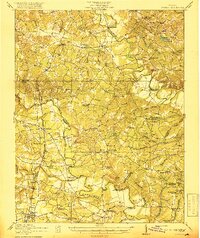
1918 Map of Doswell
USGS Topo · Published 1918About this map
The Mattaponi River and Pamunkey River systems define the low-lying terrain of central Virginia in the era before major modern development. The landscape is an intricate network of wetland drainage, featuring significant tracts such as Reedy Swamp and Boot Swamp, where early industry is represented by Reedy Mill and Bucks Mill. This 1918 survey documents a segregated educational and social landscape, specifically labeling facilities like the Penola School (Colored), School No 8 (Colored), and the Reformatory for Boys (Colored) near Hanover.
Find a feature on this map
110 named features on this map. Tap any name to fly to it.
Don’t see what you’re looking for? This feature index may not catch every label — zoom into the map to look around manually.
Map Details
Editions of this 1918 Doswell Map
4 editions found
Other maps of this area

1887 · Spottsylvania
USGS Topo · 1:125,000

1889 · Fredericksburg
USGS Topo · 1:125,000

1890 · Goochland
USGS Topo · 1:125,000

1892 · Fredericksburg
USGS Topo · 1:125,000

1892 · Spottsylvania
USGS Topo · 1:125,000

1892 · Goochland
USGS Topo · 1:125,000

1894 · Fredericksburg
USGS Topo · 1:125,000

1894 · Richmond
USGS Topo · 1:62,500

1895 · Richmond
USGS Topo · 1:62,500

1918 · Doswell
USGS Topo · 1:62,500